
The Inspiration Point loop at Tilden Park is one of my favorite walks. Despite being less than 15 minutes from downtown Berkeley, it feels like the middle of the wilderness. It’s a nice but not super-difficult 90 minute walk. There are usually enough other dogs on the trail to allow for some socialization but never does it feel crowded.
The Inspiration Point Loop at Tilden Park is Great
- A moderate 60-90 minutes, easy enough to be accessible for most people and dogs.
- Beautiful trail with sweeping panoramic views of the park
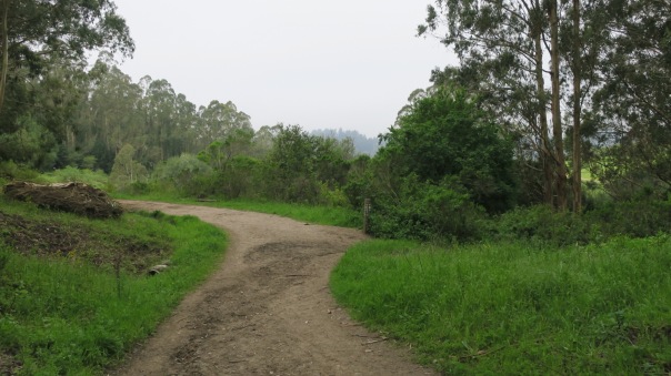
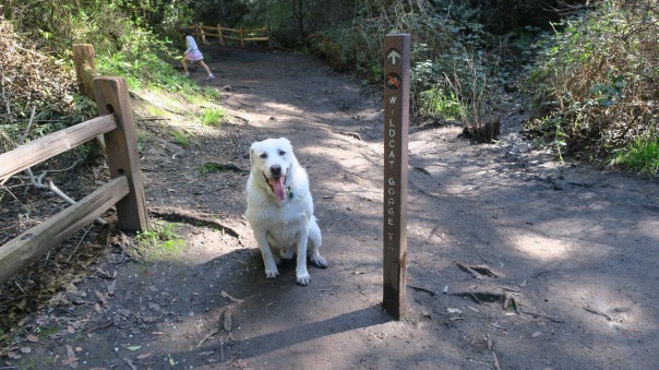
- Easy to navigate – only three turns and they are clearly marked (see below)
- Dogs allowed off leash
- There are enough other people and dogs around to feel safe and provide some four footed socializing, but never does it feel crowded
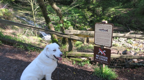
- Water is available Lone Oak, a little before the half way point of this short-ish walk, so you shouldn’t need to carry any (unless of course you start at Lone Oak, and then on a really hot day you might want some)
- Cell phone reception on some parts of the trail
- Parking is not an issue
Of Course, It’s Not Perfect
- Beautiful though it is, the Inspiration Point loop doesn’t have some of the amazing city views available elsewhere in the park
- Bicycles are allowed on most of the trail. Typically they aren’t moving very fast and I’ve never had an issue, but would still prefer they weren’t there
Klondike Walk Score: 87%
The loop at Inspiration Point doesn’t have the incredible variety of Roberts Recreation Area or the views of Strawberry Canyon but it’s beautiful, immersive, convenient, a good walk for the person and a wonderful place for a dog to enjoy being a dog. If it weren’t for the (rare) bicycle the score would be at least five points higher.
About The Park
Tilden, part of the East Bay Regional Park District, is a large (2079 acres, to be precise) slice of wilderness, running from the Berkeley Hills area to above Albany, El Cerrito and even East Richmond.
Tilden is truly an amazing place with fantastic views of San Francisco and Mount Diablo, the Anaza River, in which swimming is allowed, tons of trails for hiking, horseback riding and bicycling, a golf course, miniature railroad, Merry-Go-Round, two botanical gardens, one belonging to the park, and the other just down the road belonging to UC Berkeley. Not all of these views are available on the trail, but you can get most of them by stopping at scenic view areas on your way to or from the walk.
Dogs are allowed in most areas of the park and on most trails. Exception: Dogs aren’t allowed in the botanical gardens, and in most of the officially designated Nature Area, marked below on the official Tilden map with a rectangular box. Dogs are allowed off-leash more than 200 from trailheads. Here is a full set of dog rules covering Tilden and all other parks in the East Bay Regional Park District.

Getting There
Inspiration Point is located on Wildcat Canyon Road. Here is a google link.
Depending on where you are coming from, I urge you to take Centenial or Marin Avenue. Some GPS’s may try to route you via other, smaller streets in the Berkeley Hills. These streets can be extremely narrow and often have cars parked on them forcing you into the left hand lane on blind curves. I’ve done it, but it’s not fun.
The Walk: Inspiration Point Loop

What we call the Inspiration Point Loop starts in the Inspiration Point Parking lot, goes down the Meadows Canyon Trail, at the Lone Oak Picnic Area you go onto Wildcat George Trail and then back up to the Inspiration Point parking area on the Curran Trail. Total length is just under three miles. Meadows Canyon is a (mostly) very gentle downhill and Curran Trail is a steady, but not too steep, 1.4 mile climb up. The total walk, with a little time for sniffing, is just about 90 minutes.
I think just about anyone capable of walking three miles can do this walk. My only caution would be after rains parts of it can get pretty muddy and even a bit slippery.


Of course, one of the greatest things about any of these hikes is making new friends. This is Klondike and his new trail buddy Tango.
While Tango and Klondike played, Tango’s person told me about finding a severed deer leg not too much further down the trail. Probably ripped off by a mountain lion, who ate the rest of the deer elsewhere. Ouch.I’ve also heard of coyote sightings on the trail.


I thoroughly enjoyed the blog and the pictures (especially the one of you and Citizen K on the bench). No one could have been more comprehensive or more informative. I think it’s really a terrific article.
Love, your first (and foremost) fan
Sent from my iPad
>
LikeLike
Thanks mom!!!
LikeLike
I really enjoyed this. I live in Texas so it wouldn’t be very easy for us to walk it. We always fly to California and leave the dogs at home. They have a sitter who stays with them 24/7.
LikeLiked by 1 person
Thanks Anna! If you ever do drive out drop us a line and maybe we can do a joint walk!
LikeLike
I’d love to do a joint walk and Buster would be very happy. He became a hero to us. He and our smaller mixed breed dog started scratching at our bedroom door. By the time I got the bedside lamp on, they were banging on the door. I realized my husband wasn’t in bed when I turned the light on. I went downstairs with dogs dancing around me. My husband was on the floor, flailing around. He’s diabetic and his blood sugar had dropped. I couldn’t get candy or a coke into him because he’d swat my hands away. I called 911. Our police force is cross trained as EMTs and the first officer was here in under 2 minutes. He must have been close. Neither he or I could get a finger stick because Hubs is strong and was not coherent. 3 more officers were there in a couple minutes and we got the finger stick. Blood sugar was 34. Paramedics got here shortly after and finally got a good vein for the IV. Our doctor sent a rescue kit for me and told me to get the icing in a tube at the grocery store (but to make sure it was sugar and not HFCS). He’s trying to find the best combination of meds and timing, so it doesn’t happen again. I still can’t figure out how the dogs banged on the door. Paws? Body slam?
LikeLiked by 1 person
Wow!!! Aren’t dogs just amazing! I hope the dogs got a steak or two for the save!!
I’m just grateful that your husband is OK. Sounds like a call way too close for comfort! And it also sounds like you’ve got a great police force!
LikeLike
He isn’t stable yet, but I’m on guard for the first sign and so is he. But those dogs did get steaks but unfortunately it was too late for them to understand why. But they were very happy to eat them. I’m probably the only person who takes a tube of icing to bed! However, running up and downstairs should firm up those glutes. OK, I’m 72 so don’t actually run, just go faster than usual. I’m hoping it counts for some exercise since I usually swim 4 days a week, but won’t go to the Y and leave Hubs. We’ll get this worked out with a log of meds, food, time, etc. Tuesday we’ll sit down with the doctor and the log and try to figure it out. Thanks for your supporting post!
LikeLike
Great blog, Klondike! Now if I can only get my dad to make a similar one for me! Woof, woof, bow wow, etc.– Your pal Buddy
LikeLiked by 1 person
Buddy!!! Dude!!! Just ask your dad nicely and I bet he comes through!!!
LikeLike